
State of Michigan
Education
Michigan Open Data Portal
The State of Michigan set out to make its government data easy for the public to explore. Evolve Blue designed and built the Michigan Open Data Portal, a web application where people can search datasets, filter by agency and format, and work with geographic data through an interactive GIS section. State employees sign in through MiLogin, the state's federated identity system, while the public can browse and download data without an account.
Technology Stack
01 Overview
State of Michigan engagement context.
Government data is valuable, but it is only useful when people can find it. Datasets spread across agencies and formats are hard to search, compare, and download. Without a single front door, residents, researchers, and staff spend time hunting for data instead of using it.
The goal was to give Michigan a single, accessible portal where the public can search, filter, map, and download government data, and where state employees can sign in securely to access account-based features.
The audience included Michigan residents, researchers, civic developers, and state agency employees who need to find and work with government datasets.
Evolve Blue designed and built the Michigan Open Data Portal web application, including the search experience, filtering, the GIS data section, and integration with the MiLogin sign-in flow.
02 The Challenge
State of Michigan constraints to solve.
- Government datasets were spread across multiple agencies and formats, making them difficult to discover.
- No single searchable portal existed for residents, researchers, or state staff to find and compare data.
- Geographic data required specialized tools for mapping, analytics, and visualization that were not centralized.
- State employees needed secure authentication consistent with Michigan's federated identity system.
- The portal had to serve both authenticated state users and the general public without accounts.
- Datasets in CSV, JSON, Excel, PDF, and geospatial formats needed a consistent way to browse and download.
03 The Solution
State of Michigan solution architecture.
Evolve Blue delivered a public-facing data portal organized around how people actually look for data. The home page leads with a search bar that returns live suggestions, shows result counts, and highlights matching terms. Visitors can filter datasets by agency, year, and format, and reach featured datasets or a bulk download.
The portal includes a dedicated Michigan GIS Data Portal with four areas: an interactive county map with selectable data layers, GIS datasets, spatial analytics with trend and comparison charts, and GIS tools for managing and visualizing spatial data. The GIS section connects to external mapping services and documents its API.
State employees sign in through a MiLogin modal, keeping authentication consistent with Michigan's federated identity system. The public can browse and download data without creating an account.
Dataset search
Dataset search with live autocomplete suggestions, highlighted terms, and result counts.
Agency filtering
Filtering by agency, year, and data format, plus featured datasets and bulk download.
Interactive GIS map
Interactive county GIS map with selectable data layers and a population density legend.
Spatial analytics
Spatial analytics with county trend charts and population-versus-budget comparisons.
GIS tools
GIS tools for uploading, validating, converting, and visualizing spatial data.
MiLogin sign-in
MiLogin sign-in integration for state employees, with public access kept open.
04 What We Built
State of Michigan delivery objectives.
Build a unified data portal with search, filtering, and download for Michigan government datasets.
Deliver dataset search with live autocomplete suggestions, highlighted terms, and result counts.
Enable filtering by agency, year, and data format, plus featured datasets and bulk download.
Create an interactive GIS data section with county maps, spatial analytics, and geospatial tools.
Integrate MiLogin federated identity sign-in for state employees while keeping public access open.
Support geospatial formats including GeoJSON, Shapefile, KML/KMZ, and GeoTIFF alongside standard data formats.
05 Government Data Portal
Michigan Open Data Portal in focus.
The portal combines dataset search, agency filtering, interactive GIS mapping, spatial analytics, GIS tools, and MiLogin sign-in into one public data experience.
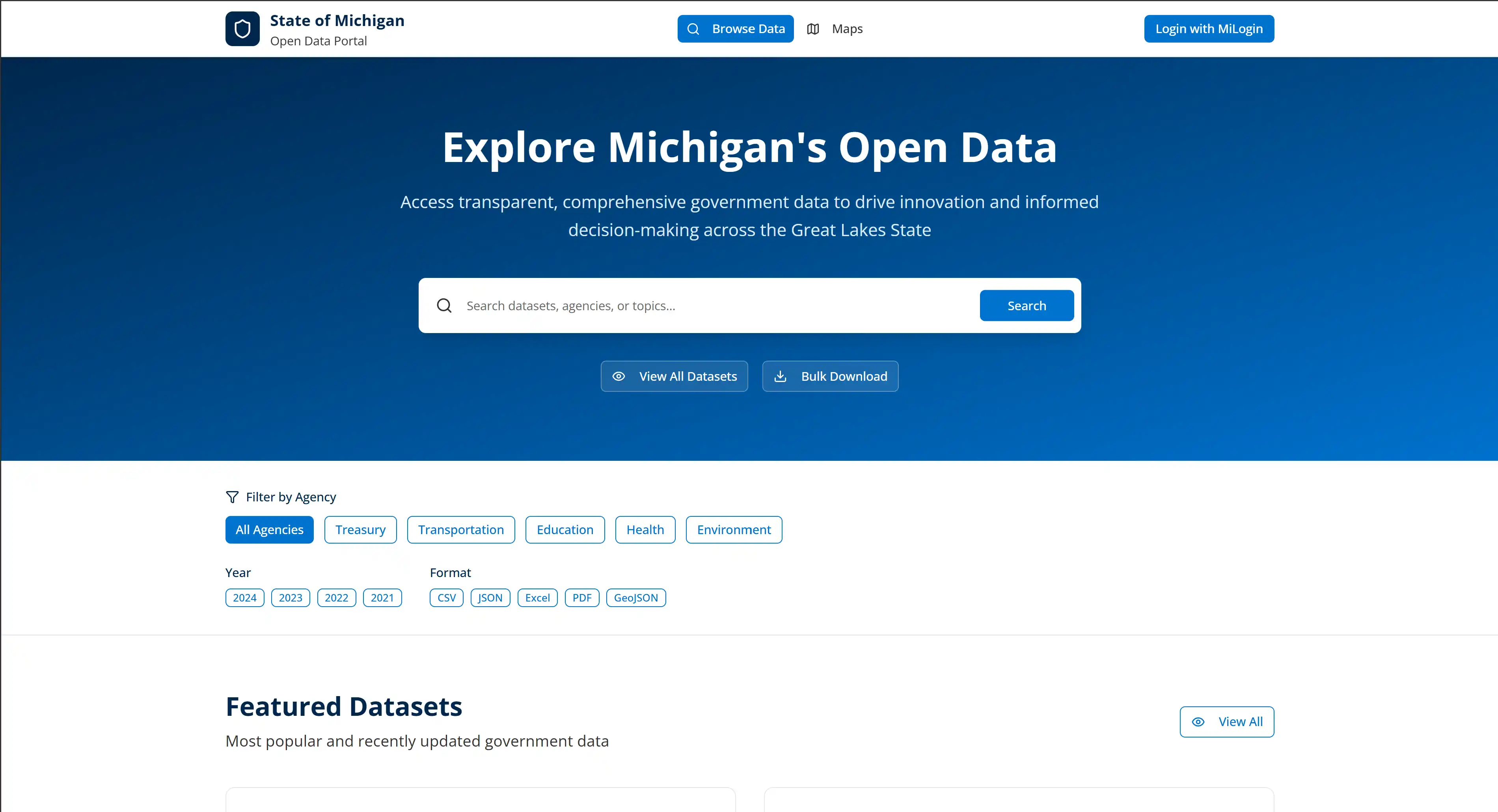
Portal home page with search bar and agency filter chips.
06 Implementation Journey
State of Michigan delivery journey.
Discovery
Reviewed how residents, researchers, and state staff search for and use government data, and identified the need for one searchable, filterable portal.
Design & Planning
Defined the portal structure — search and browsing, agency and format filtering, the GIS section, and the MiLogin sign-in flow — and designed screens around each user path.
Build & Implementation
Built the search experience with autocomplete and filtering, the interactive GIS map, spatial analytics, GIS tools, and the MiLogin integration.
Launch & Support
TBD
07 Before / After
From scattered government data to one searchable portal.
The engagement moved Michigan's government data from fragmented agency sources to a single portal with search, filtering, interactive GIS maps, and secure MiLogin access.
Fragmented data landscape
Government datasets were spread across agencies and formats, making them hard to find, compare, and download.
One unified data portal.
A single portal lets the public search, filter, map, and download Michigan government data, with secure MiLogin access for state staff.
Before
- Government datasets were spread across agencies and formats, making them hard to find.
- No centralized search existed for discovering datasets by keyword, agency, or format.
- Geographic data lacked a unified mapping, analytics, and tool interface.
- State employees had no consistent sign-in experience tied to Michigan's identity system.
After
- Datasets are searchable in one place, with filtering by agency, year, and format.
- Geographic data is explorable through an interactive map, analytics, and GIS tools.
- State employees authenticate through MiLogin, while the public can browse and download without an account.
- Featured datasets and bulk download options reduce the time spent locating data.
- Spatial analytics provide county trends and population-versus-budget comparisons.
08 Impact
State of Michigan implementation outcomes.
Centralized dataset discovery
Datasets are searchable in one place, with filtering by agency, year, and format.
Interactive geographic exploration
Geographic data is explorable through an interactive map, analytics, and GIS tools.
Secure and open access
State employees authenticate through MiLogin, while the public can browse and download without an account.
09 Capability Mapping
Capabilities applied for State of Michigan.
Build & Modernize
PrimaryWeb application with dataset search, autocomplete, filtering, interactive GIS maps, spatial analytics, GIS tools, and MiLogin integration.
Automate Workflows
SupportingLive autocomplete, result highlighting, and format-aware filtering reduce manual steps in dataset discovery.
Run Cloud & Operations
SupportingPublic-facing web portal supporting daily data access for residents, researchers, and state employees.
10 Conclusion
Why the State of Michigan engagement mattered.
The State of Michigan needed a single front door for government data — one that served residents, researchers, and state employees without requiring technical expertise.
By building a searchable portal with live autocomplete, agency and format filtering, interactive GIS mapping, spatial analytics, and MiLogin integration, Evolve Blue gave Michigan a public data experience that makes government data easy to find and use.
More Client Work
Explore related case studies.
See how Evolve Blue solves similar delivery problems across industries.
Start your project.
Evolve Blue helps organizations design and build data portals, search experiences, and geospatial applications that make complex information accessible.